
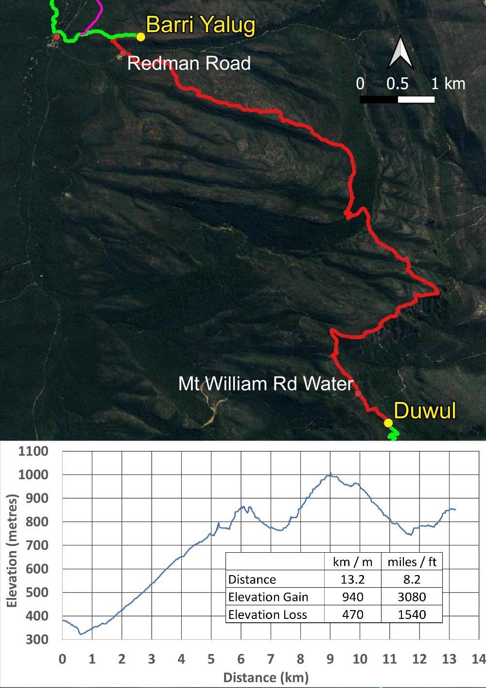
Barri Yalug to Duwul
We respectfully acknowledge the Djab Wurrung and Jardwardjali people as the traditional custodians of the lands and waters of Gariwerd.
Big climbs, vast views and stories in the landscape

A very early start, backtracking north towards Lake Bellfield. You can see Mt Rosea that you climbed yesterday, as well as the Wonderland Range you traversed the day before.
Today’s hike of 13.2km has a 940m elevation change, the largest on the entire Grampian’s Peaks Trail. Nor is it manicured: much of it is across sloping rock slabs, followed by many scrambly bits as you follow the Seven Dials to Redman Bluff. Lake Bellfield is behind you growing ever more distant, with new views opening up to the east, south and west ahead. And although day hike options exist in the region, you’ll likely see few or no people on the track, so most of the time you’ll have those magnificent views to yourself.

The overview map
Although today is rated Grade 4, many hikers consider it more demanding than tomorrow’s Grade 5 hike; the latter grading will certainly apply in bad weather where the exposed Major Mitchell Plateau will be more treacherous than the lower elevations seen today (though whiteout conditions can still occur). However, in benign weather, we think today is tougher. Here’s why!
This is not new track like much of the Northern Section, but existing ones that have been cobbled together. Many of these trails were always less traversed than the popular Wonderland Circuit, and cater to more experienced hikers. The old tracks haven’t been upgraded except for yellow track markers. You’ll need to watch every single footstep on the rocky substrate and, rather than a long steady ascent, you have many more ups and downs; Geoff calls them humpty-doos. Many people find this kind of elevation gain more tiring than a single steady ascent followed by a steady descent as you had yesterday.
Despite this, it is eminently doable and the views and wildlife are every bit worth the effort. Many people even run this and double-hut but, if you are reading our blogs, you are likely not one of them! I’m slow, far from strong and I was carrying a knee injury. I found it tough but still completed it, though there may have been a little dummy spit along the way! With realistic expectations you too can plan the day to match your ability.
How to Make Today Easier
By far the best option for slower hikers is to start early, very early. I covered the distance in eleven hours, and other hikers on the same day weren’t much faster. But few people will be as slow as me and I didn’t hurry. When you are not hurrying, you can manage the scrambles at your own pace. Hiking at your own pace removes stress — “Will I reach camp before dark?” (this isn’t a route ideal for night hiking) — and reduces the chance of being taken off the track through ankle and knee injuries.
You can also lighten your pack by being smart about water refills. Like all GPT campgrounds without shelters, Duwul only has a small tank attached to the (equally small) toilet roof so, at some times of year, you’ll need to carry water for the evening and morning. There is a reliable roadside tank about a kilometre before you reach Duwul, so you need only carry enough water for today’s hike.
If, after looking at this blog, you think today is beyond you, don’t give up on the rest of the trail. In Central Section Planning and Tips, Geoff suggests ways to skip today and/or tomorrow by using track transfers, or by hiking back into Halls Gap from Borough Huts or Barri-Yalug today, then getting a transfer to Mt William or Jimmy Creek tomorrow. You have more wonderful walking beyond these next two days: don’t ever be afraid to adjust a standard itinerary, including splitting or bypassing days, to bring it within your capability.
Walk with Us:

A very early start and more of that marvellous 140-year-old water flume. You can read interpretive signs describing its construction.

At the start of the long and steady ascent up the Seven Dials Range, looking behind towards Mt Rosea.

Violet Kunzea (K. parvifolia)

Beard Orchid (Calochilus robertsonii)

Time for a breather. You will enjoy many more views of Lake Bellfield from the Seven Dials Range. You can see the gently sloping rock slabs of the westerly aspect here…

…contrasted with the steep escarpments of the east-facing aspects here. This landform is known as a cuesta and happens when earth movements tilt sedimentary rock.
As well as using the sun, you can often orient yourself by using consistent landforms like this; notice the lie of the land in following images to see if you can work out N/S/E/W. The Seven Dials Range has seven rocky outcrops along its length, and following the edge of that tilted sediment we pass five of them.

The terrain is rugged.

Lake Bellfield slowly shrinking.

Up, down, around and between!

Lunch time with wonderful views (remembering the cuesta landform, can you guess which way Geoff is facing?).
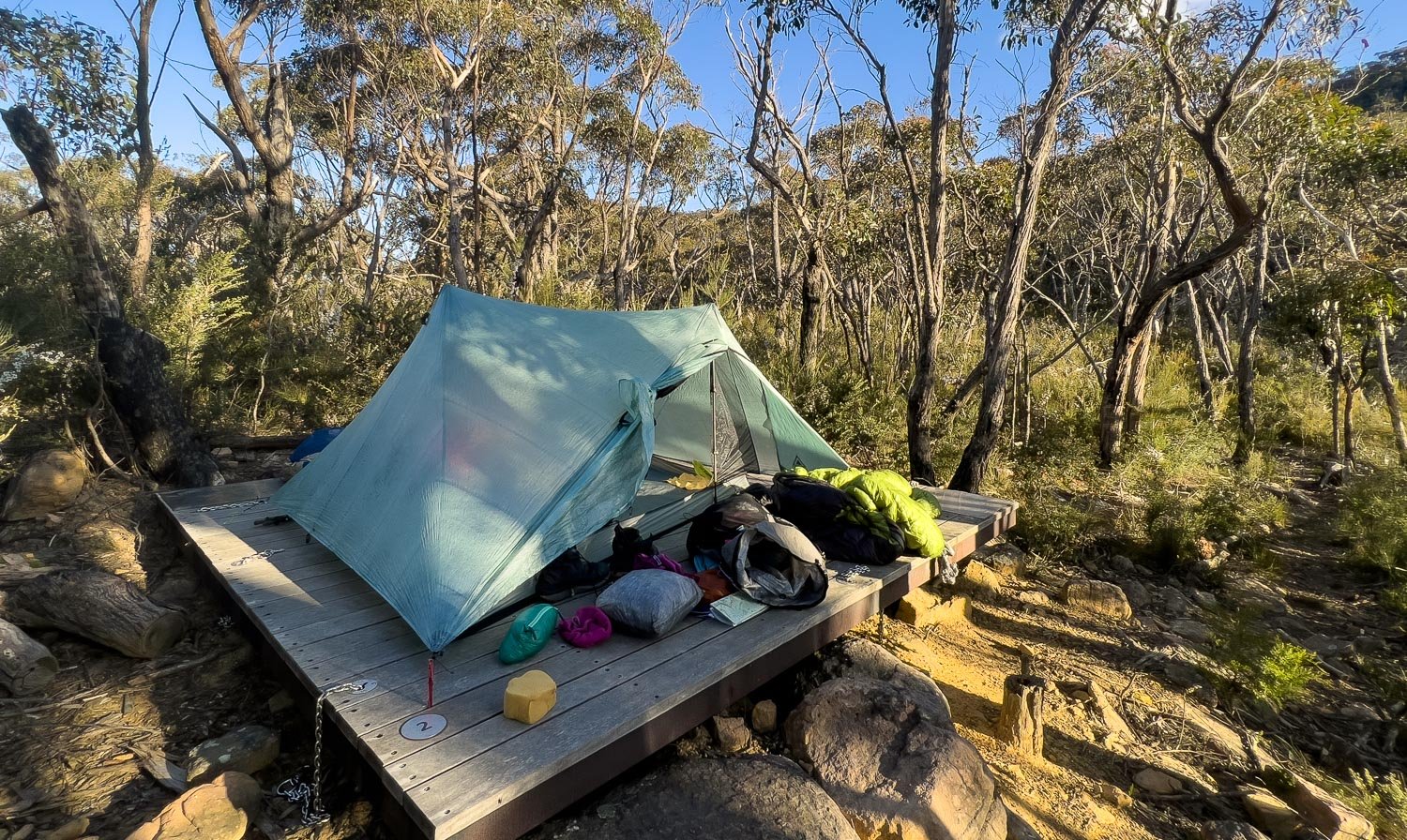
You can see last night’s damp being aired from our down twin quilt. We use a twin quilt and two sleeping mats strapped together, and have found it not only extremely light but also a sleep system that most closely resembles sharing a bed at home; we highly recommend it for well-established couples of similar height who want to save weight, and who usually hike together rather than individually. We’ve used it down to about -4 C and with xtherm mats we expect it to comfortably go to about -10C: as long as you choose the right design it’s warmer than you think because two bodies are sharing the same space (more on ultralight sleep systems for couples here).

Descending from the Dial after lunch.

Some of these images look as if the scrambling has a lot of exposure but, don’t worry, it does not. You will not plummet to your death!
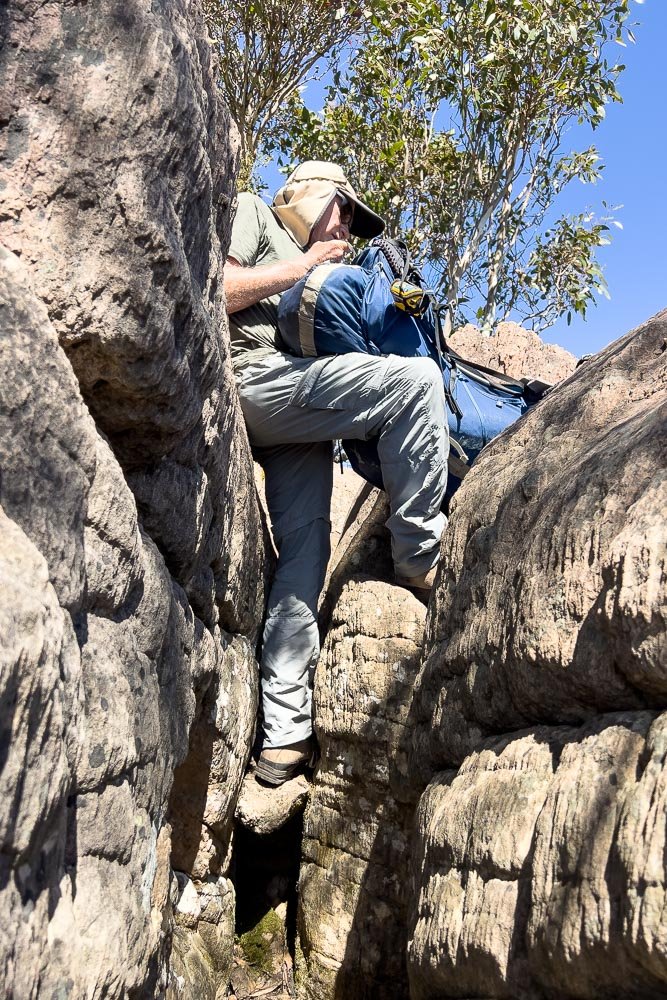
This was a particularly narrow scramble: we had to pass our packs through.

Down, down, down that escarpment.

A beaut Jewel Beetle, Stigmodera macularia, almost always seen on tea tree.

In a little hollow, but we’re far from done yet!

Mountain Greenhood (Pterostylis alpina)

Remember that classic cuesta landform? You can clearly see that tilted rock here.

A final view back over Lake Bellfield before it disappears.

More reptile humpy-rumpy, here eastern brown snakes. These were totally into each other and didn’t notice us but, if you are ever faced with a frightened snake with its head raised to strike, freeze: any movement, even backing away, can be seen as a threat and further frighten the snake. After a few moments, it will lower its head and slither away. Geoff and I warn each other with the word “Stop!” rather than “Snake!” to reinforce the appropriate action.

You can see in this image how rugged the terrain is through here, with Redman’s Bluff head. The GPT follows the rock; there is very little construction, but many hikers prefer this more natural form of track. I usually do too, but am somewhat over it today!

The uneven rock is extremely tiring and slow going.

Past a pretty pool.

Golden Heath (Styphelia adscendens)

At last descent from Redman Bluff.

Almost no more pictures from me. I’m on a death march into camp!

But the beauty of the landscape remains for one last photo.
At Duwul at last, thank the gods! My diary entry for the day reads simply, ‘Exhausting!’

Dinner at sunset. It has been a Very Long Day but the sense of accomplishment almost makes up for it! We made it!
But seriously, the views have been grand, the GPT delivers and delivers and delivers. The memories you make here will stay with you for life. Worth the pain after all, I reckon!