
Wannon to Djardji-djawara
Open swamp, forest and a contouring climb with views east and west
We respectfully acknowledge the Djab Wurrung and Jardwardjali people as the traditional custodians of the lands and waters of Gariwerd.

Finally on that tantalising Serra Range today, and it lives up to its promise!
Today’s 16.3km/10.2mi hike takes us across the Grampians Valley with seasonal swampland before climbing onto the Serra Range at last. You have seen teasing views of this range for days and, after a beautifully contouring ascent, you will spend almost all day following its spine, with views both east over farmland and west across the Victoria Valley to the Victoria Range. In the late afternoon (for slower hikers), you’ll descend the range’s eastern flanks to reach the hut.

Today’s elevation profile still shows a decent elevation gain but, remember, the track is much smoother than in the Central Section.
Once again after those challenging track surfaces of the Central Section, you will be pleasantly surprised by today’s much less rocky terrain and the daily distance, whilst longer than many others on the GPT, is therefore still very doable - just take it easy up the long main climb of the day.
How to Make Today Easier
At 16.3 km, this is one of the longer ones of the GPT but don’t be daunted: the track is much better formed. An early start is helpful, especially if you are hiking in late autumn or winter with fewer daylight hours.
No need to carry water for the full day: top up at the serviced Griffin Trailhead water tank about one fifth of the way in for the day at 3.2km/2mi. It’s also the perfect spot to stash a food drop in an animal-proof plastic tub or barrel; hide it discreetly as day hikers use the area. Daily food drop stashes will make a huge difference in your pack weight.
For those who want to split the day, the Griffin Trailhead is also an opportunity for a car shuffle or track transfer company for a night in Dunkeld, though transfers to and from here will be expensive.
Walk with Us

The track starts easily enough, meandering through open woodland in the valley.

Grassy clearings as you approach the Wannon River.

Over the river via a small bridge, followed by walkway through magnificent clumps of Baloksion tetraphyllum taller than we are.

Soon you emerge onto beautiful seasonal open swampland with tea tree and countless interesting forbs; we saw many sun orchids, though they were closed in today’s cooler weather. This was one of my favourite sections of the track and botanists will relish it.

Yellow Onion Orchid (Microtis atrata) grows in seasonal swamplands. The flowers are minute, just a few millimetres across.
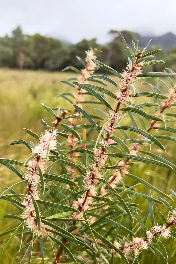
Hakea rostrata

The Serra Range grows ever closer. Soon you’ll cross the Grampians Highway but, for now, a little more of that marvellous open swamp to enjoy.

Across the highway and you’re into stringybark with a rich understorey and so many birds — gang-gangs, other parrots and rosellas, plus numerous tiny wrens and honeyeaters flitting through the bushes.

Flame Grevillea (Grevillea dimorpha) is aptly named. The leaves can be needle-like, short and wide, or anything in between! For those who are mystified by the scientific names of plants, they are very useful because they often describe a plant’s characteristic feature: di = two and morphe = form. You may not want to learn Latin, but Greek or Italian are useful. I did only three years of Latin (in an Aussie public school no less!) but, contrary to being a ‘dead’ language, it was ever-present in natural sciences tertiary study, and when learning Italian for hiking holidays there.

This orchid, Pyrorchis nigricans, normally blooms after fire in the blackened earth and is pollinated by flies attracted to its flesh-coloured flowers and, presumably, scent! The flower turns black immediately after pollination to blend with the scorched ashfield and thereby evade hungry grazing animals.
You can guess what “pyro” means, and “orchis” too in this context (but look further into this word’s derivation and you may be surprised!). Nigricans is a colour. Black fire-orchid. Pretty cool and not at all mysterious… even fun, don’t you think?

Second breakfast at Griffin Fire trail Crossing. You can walk in a few hundred metres from the car park to here and do a food drop ahead of time to reduce your pack load. A food drop every day in this section means you need carry only the evening’s meal, the morning’s breakfast and perhaps snacks and a lunch daily: see Tips and Planning on how to make the entire section easier. There is a pack of Sesame Snaps on the log. We like these for hiking with 180 calories in a 35g pack.

Although there is a water tank here, we were horrified to see no boot cleaning station. We were even more horrified later because we saw no sign of Phytopthera in the entirety of the new track in the Serra Range, whereas the latter part of the Central Section is riddled with it. We are thrilled to discover that, just a few months after we walked, a boot cleaning station was installed at the Trailhead here. Goodonya, Parks Victoria! Remember to clean your trekking pole tips as well as your boots and please be super thorough: you have been hiking through diseased areas.

Plenty of Banksia, Grevillea, and Xanthorrhoea in a marvellously healthy understorey. This is why we should all do the right thing!

Climbing the eastern side of the Serra Range: a steep but well-built track passing spectacular boulders

Steps! Yay!

Pultenea mollis

Happily, the track contours up, rather than heading straight for the spine. Ahead, the peaks you will climb later appear sporadically from the cloud.

The walking is a complete delight, with views to the east almost the entire way.

And views south, with the Serra Range’s magical peaks beckoning you onwards. You have seen these peaks for days from the William Range but here they are, growing closer.

It’s pretty wet when we hike. Walking along the spine, you’re climbing knolls and descending into gaps the entire time. But now the cloud has descended too and this is as good a lunch spot as any, with wreaths of mist blowing through the gap.

Our favourite cool weather lunch, home-made Cup a Soup and homemade crackers: yum!

Just beautiful, with so much in bloom!

Pine Heath (Stenanthera pinifolia)

Another marvellous view, across the Victoria Plain to the westernmost arm of the Grampians, the Victoria Range. You’ll find beaut walks there too.
When you are hiking on tracks like this, you really have no excuse to get caught in rain. You will see the squalls, and the direction in which they are moving. If you glance at them now and then, you’ll also be able to tell whether they are growing as they approach, and whether you are in their path. Plenty of time to don rainwear!
You can identify light squalls because they are not opaque: you will be able to see the land on the other side through them. Sometimes they are very light, as the barely visible one centre left in the ‘V’ of the lower background hills, but beware: light squalls on flat terrain may grow in intensity as they reach hills or mountains.
Conversely, we have heard heavy squalls approaching in densely forested terrain, with just enough time to put on our jackets. Use all your senses! We’ve often been amazed that many folk are completely oblivious to approaching weather, even when it is clearly visible. Situational awareness is a great skill for hikers to practise and learn.

Huge sweeps of mist are blowing in from the west through every break in the range, creating a dramatically moody ambience.

And back to the eastern views again. Wow, this track is a treat!

Such changeable weather: you really need to be prepared for anything on this hike! Here, we’re crossing a little gap, with quite different vegetation. I can’t recall if this is the exact spot where you descend off the spine and begin contouring down the eastern slopes, but it was one of very few (only?) places on the trail where we backtracked ten or so metres, having missed the small cairn on the edge marking the descent. Enough people have done the same thing that a well-worn pad has developed. This last section of trail is not well marked — it seems they might have run out of yellow traingles! — but most of the time there is simply nowhere else to walk, so no need to worry.

Many marvellously healthy Xanthorrhoeas, some with trunks as tall as Geoff.

The sharp-eyed may just make out tiny orchids growing in the centre of the track. For orchid photography, I use an OMD1 Mk 3, usually with a 12-40mm lens while travelling (great for flower shots and a good overall walkaround lens) but here, after breaking the 12-40mm in the Northern Section, I’m using my heavy 90mm macro. The 60mm macro is a good lightweight alternative to combine with a wider angle 4/3 walkaround zoom like the new 8-25. For larger flowers, I usually use my iphone 13.

Little Bronze Caps, Caladenia transitoria. Each flower is no bigger than your thumbnail!

And here is the Bronze Cap (C. iridescens), not much bigger. I didn’t realise for some time that I had been looking at two different species!

At last you are on the lower flanks and into flatter terrain, passing below ancient stringybarks

Spectacular Tinsel lily (Calectasia grandiflora)

… And finally into sand and approaching camp.

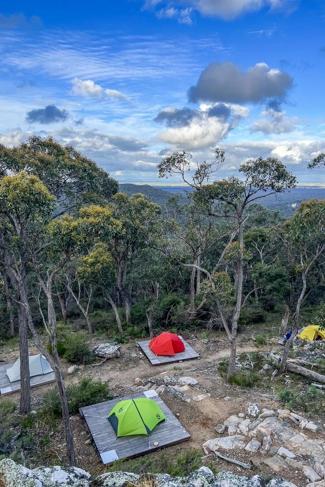
Djardji-Djarwara is a beautiful hut in a stunning location, perched on the edge of an escarpment. The campsites are a tier below, out of sight and in more sheltered terrain. The views along the Serra Range even from inside the hut are breathtaking… and look at that nice big water tank!

Here’s the layout. The communal shelter and toilets are at the top, and the tent platforms are nestled amongst the trees below.
It’s the busiest day we’ve seen on the trail thus far, with a few family groups on an overnight hike. Most days there have only been a handful or fewer in camp each night.

Our cosy spot. We have become very fast at setting up the tent on these recalcitrant platforms with few gaps! If you’re unfamiliar with the techniques, check our tips and practice. Non-freestanding tent owners, add line extensions to your guylines before you leave home.

Glorious view north along the Serra Range from beside the hut.
I know we keep saying it but, frankly, we have run out of superlatives for this hike. Even the bits that on paper seem to be least spectacular are still gobsmackingly stunning. Today had countless “Wow!” moments: it’s just that good!